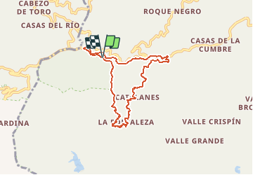
![](/images/other/stat-length.png)
Pico del Ingles circulaire
jolyjump
Benutzer
![Länge](/images/other/stat-length.png)
![Maximale Höhe](https://static1.geolcdn.com/siteimages/upload/files/1508320355ic_sort_altitude_max_24dp.png)
![Positive Höhendifferenz](https://static1.geolcdn.com/siteimages/upload/files/1508320355ic_sort_den_pos_24dp.png)
![Km-Effort](/images/other/stat-length.png)
![Min. Höhe](https://static1.geolcdn.com/siteimages/upload/files/1508320355ic_sort_altitude_min_24dp.png)
![Negative Höhendifferenz](https://static1.geolcdn.com/siteimages/upload/files/1508320355ic_sort_den_neg_24dp.png)
![Boucle](https://static1.geolcdn.com/siteimages/upload/files/16400158638029165_repeat_loop_refresh_sync_direction_icon.png)
![Zu Fuß](https://static1.geolcdn.com/sitytour/trail-icons/100.png)
4h00
Schwierigkeit : Medium
![Scannen Sie diesen QR-Code, um die Tour in der SityTrail-Anwendung zu öffnen](https://capi.geolives.com/qq0zvz2zws4bq2lad0pu/sitytour/trails/2327686/qr.png?size=200)
Kostenlosegpshiking-Anwendung
Über SityTrail
Tour Zu Fuß von 9,2 km verfügbar auf Kanarische Inseln, Santa Cruz de Tenerife, Santa Cruz de Tenerife. Diese Tour wird von jolyjump vorgeschlagen.
Beschreibung
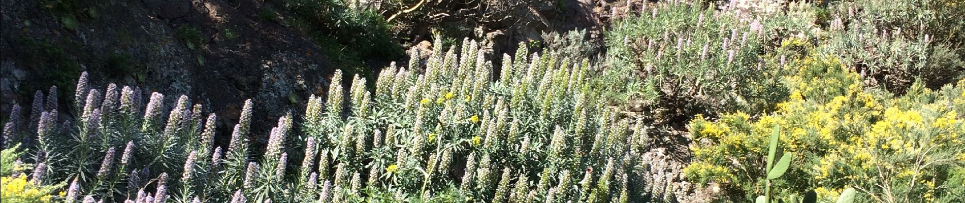
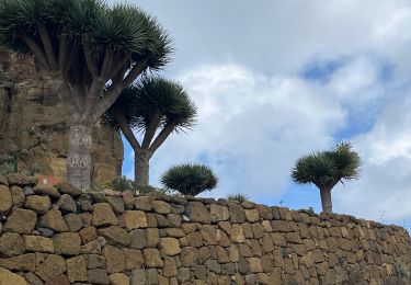
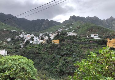
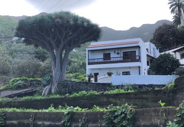
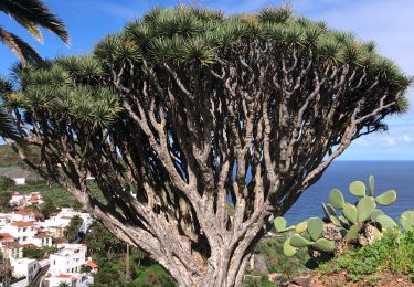
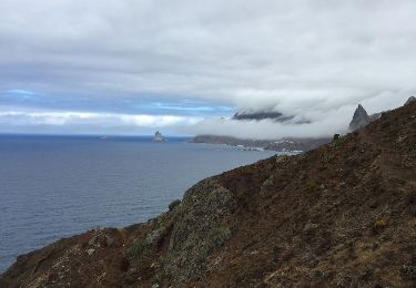
Ancien camino de communication surplombant l'Anaga. Très belle rando débutant dans les laurisilvas, les bruyères arborescentes. Nous croisons quelques fermes et cultures en terrasse. Les aloes et figuiers de barbaries font suite à notre balade ainsi que de nombreuses fleurs printanières.
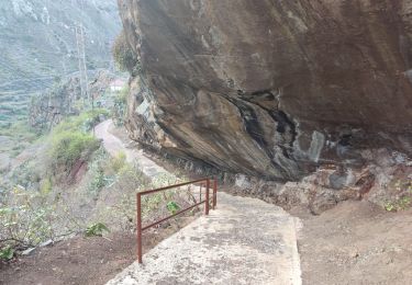
Nous rejoignons une route en ciment à Catalanes puis goudronée.
07/02/2020
Ort
Kommentare
Touren in der Umgebung
![Tour Wandern San Cristóbal de La Laguna - Massif de l'Anaga El Batan Chinamada - Photo](https://media.geolcdn.com/t/375/260/bf287400-cf63-4351-bbc9-dbe9aba0fa64.jpg&format=jpg&maxdim=2)
![Wandern Wandern](https://static1.geolcdn.com/sitytour/trail-icons/101.png)
Wandern
![](/images/other/stat-length.png)
![](https://static1.geolcdn.com/siteimages/upload/files/16400158638029165_repeat_loop_refresh_sync_direction_icon.png)
![Tour Zu Fuß Tegueste - El bosque de los enigmas - Photo](https://media.geolcdn.com/t/375/260/1a03fed7-fb28-4a0e-9d0f-13adda6bed3b.jpeg&format=jpg&maxdim=2)
![Zu Fuß Zu Fuß](https://static1.geolcdn.com/sitytour/trail-icons/100.png)
Zu Fuß
![](/images/other/stat-length.png)
![](https://static1.geolcdn.com/siteimages/upload/files/16400158638029165_repeat_loop_refresh_sync_direction_icon.png)
![Tour Wandern Santa Cruz de Tenerife - 20230128 boucle Tâcheron - Amalciga - Photo](https://media.geolcdn.com/t/375/260/b1f1dc85-b9e4-4caa-b65a-f459c97ad4be.jpg&format=jpg&maxdim=2)
![Wandern Wandern](https://static1.geolcdn.com/sitytour/trail-icons/101.png)
Wandern
![](/images/other/stat-length.png)
![](https://static1.geolcdn.com/siteimages/upload/files/16400158638029165_repeat_loop_refresh_sync_direction_icon.png)
![Tour Wandern Santa Cruz de Tenerife - 20230123 Tachero-Taganana-Afur-Tamarides-Taganana - Photo](https://media.geolcdn.com/t/375/260/5e74cb13-69fc-4368-a6b5-97a9ce371819.jpg&format=jpg&maxdim=2)
![Wandern Wandern](https://static1.geolcdn.com/sitytour/trail-icons/101.png)
Wandern
![](/images/other/stat-length.png)
![](https://static1.geolcdn.com/siteimages/upload/files/16400158638029165_repeat_loop_refresh_sync_direction_icon.png)
![Tour Wandern Santa Cruz de Tenerife - 20230121 Tacheros-Taganana- el Baleiros - Photo](https://media.geolcdn.com/t/375/260/d3298b11-553a-417f-a8c1-0c2a9e5ffc75.jpg&format=jpg&maxdim=2)
![Wandern Wandern](https://static1.geolcdn.com/sitytour/trail-icons/101.png)
Wandern
![](/images/other/stat-length.png)
![](https://static1.geolcdn.com/siteimages/upload/files/16400158638029165_repeat_loop_refresh_sync_direction_icon.png)
![Tour Wandern San Cristóbal de La Laguna - Las Carbonaras Chimada AR - Photo](https://media.geolcdn.com/t/375/260/b1c626c3-3510-4ce3-890e-282b82838da6.jpg&format=jpg&maxdim=2)
![Wandern Wandern](https://static1.geolcdn.com/sitytour/trail-icons/101.png)
Wandern
![](/images/other/stat-length.png)
![](https://static1.geolcdn.com/siteimages/upload/files/16400158638029165_repeat_loop_refresh_sync_direction_icon.png)
![Tour Wandern Santa Cruz de Tenerife - Afur - Taganana - Photo](https://media.geolcdn.com/t/375/260/3c968652-f4ba-48a3-a0da-108b9b20f163.jpg&format=jpg&maxdim=2)
![Wandern Wandern](https://static1.geolcdn.com/sitytour/trail-icons/101.png)
Wandern
![](/images/other/stat-length.png)
![](https://static1.geolcdn.com/siteimages/upload/files/16400158638029165_repeat_loop_refresh_sync_direction_icon.png)
![Tour Andere Aktivitäten Santa Cruz de Tenerife - taganana afur taganana par la mer - Photo](https://media.geolcdn.com/t/375/260/ext.jpg?maxdim=2&url=https%3A%2F%2Fservices.sitytrail.com%2FGeolivesWS%2FDownloadMedia.ashx%3FTrailID%3D1023224%26Media%3D20180816164504.jpg)
![Andere Aktivitäten Andere Aktivitäten](https://static1.geolcdn.com/sitytour/trail-icons/900.png)
Andere Aktivitäten
![](/images/other/stat-length.png)
![](https://static1.geolcdn.com/siteimages/upload/files/16400158638029165_repeat_loop_refresh_sync_direction_icon.png)
![Tour Wandern San Cristóbal de La Laguna - Cruz del Carmen al Mar Bajamar - Photo](https://media.geolcdn.com/t/375/260/ext.jpg?maxdim=2&url=https%3A%2F%2Fservices.sitytrail.com%2FGeolivesWS%2FDownloadMedia.ashx%3FTrailID%3D908007%26Media%3Dfix__20180218155348.jpg)
![Wandern Wandern](https://static1.geolcdn.com/sitytour/trail-icons/101.png)
Wandern
![](/images/other/stat-length.png)
![](https://static1.geolcdn.com/siteimages/upload/files/16400158638029165_repeat_loop_refresh_sync_direction_icon.png)